The Owyhee – Tough Trip Through Paradise
January 2, 2012

By: Shane Moser
During early spring my skin starts itching for whitewater. Things are happening. Mountain snow is surging and receding with passing storms, tending to recede a bit more with each storm than the previous, a tell-tale sign of the end of winter in Idaho. Animals are at a critical time having survived the winter and are grazing voraciously in the low ground and on sun-exposed slopes. Early steelhead start heading for spawning waters, having spent the winter in an environment of ice. All this signals the coming melt – high water. And the anticipation of high water gets me excited to go floating, to witness the break up, to participate in it, to be a part of the annual transition from winter to spring. The excitement is electric, naturally leading the excited river runner to a study of rivers which might be possible to float at that time of year. In Idaho, such a study will eventually lead the excited river runner to the Owyhee Canyonlands.
Looking Down on Camp photo: Shane Moser
When river runners hear about Idaho, they likely conjure images of our flagship rivers – the rugged streams flowing from pine and fir forests among the jagged mountains of Central Idaho, the Middle Fork and Main Salmon. From a paddler’s point of view the character of Idaho’s big rivers – those rivers of the central Idaho mountains – has a certain amount of consistency. The rapids have a flow. Horizon lines ramp up the ‘alert meter’ so to speak, but one can almost always pick out similarities. Reading and running, a common skill for navigating rapids can be readily learned and applied with some amount of reliability. Though every river has a unique ‘feel’ to its flow, its rapids, its horizon lines, virtually all of Idaho’s big river drainages stem from the same region – the region known as the backbone of Idaho dividing the Frank Church River of No Return Wilderness Area and the Selway-Bitterroot Wilderness Area. Since Idaho’s flagship rivers originate in the same general region, they receive generally similar weather, they stem from similar geology and contain homogenous bio-systems. It follows that the character of these rivers should also be similar. Thus the actual feel of the whitewater, oars or paddles in hand, can also be drawn into the category of ‘similar’ when floating rivers from the same region.
[youtube]0irmVvGDL5M[/youtube]There are literally lifetimes of personal discoveries to be made on any given river, so for many people, all the splendor that makes our flagship rivers great, has become status quo. People are often satisfied with calling themselves an Idaho River Runner having run the rivers of the Salmon or Clearwater drainages. We forget that Idaho was coined ‘the Whitewater State’ NOT simply because of the rivers that make up our flagship runs. In fact, more likely this term was coined due to all the other wonderful runnable streams and tributaries in Idaho.
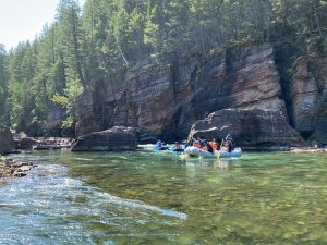
Enter the Owyhee. And exit any preconceived notions about Idaho river running. The Owyhee is a true desert river. It flows during winter and spring through Sage and Juniper canyonlands, when cloud banks create an ever-changing time lapse of shadows and sunshine on the melting desert landscape below. The Owyhee can run nearly dry during the heat of summer, with the occasional flow spike following spotty rainstorms across the vast sage steppe that is “ION country” (the Owyhee Canyonlands are often referred by local historians as ION country, for Idaho-Oregon-Nevada). Find out more on Oregon’s Owyhee Canyonlands at www.wildowyhee.org, they are trying to gain the same protection for the Owyhee Canyonlands on the Oregon side. The Owyhee River boils through sieve-rapids. Boats react in a different fashion than they would in a mountain river – the water is very powerful in an almost lethargic manner. An oarsman no longer feels the constant gradient and flowing series of moves necessary in central Idaho. Instead, desert rivers require the floater to adjust from the read-and-run flow to a crucial game of timing. One must read boil lines, waiting for the exact instant when a stroke is needed to keep the boat in the current. Water dams up above a rapid in pools that feel like the calm before a storm, making reading bubble lines and guessing the thalweg as critical to trip progress as scouting a rapid. There are often multiple routes through the sieve-style rapids. For someone used to the status quo, the desert environment emerges as an entirely new experience.


Owyhee Falls (18,000 cfs on Rome gauge, 100 miles downstream) photo: Shane Moser
Any trek from the river gorge will yield new discovery whether it be a wrangler’s cabin in the rocky bottom, or an ancient pictograph, petroglyph, or hunting blind hidden in the talus. If one is lucky enough to find a place in the river gorge where it is possible to rim out, trekking possibilities are endless. Wild horses and antelope, mule deer and desert elk, even mountain sheep, roam this southwest corner of Idaho and Eastern Oregon. In addition, birders will be radically astounded. The upper river begins in Duck Valley, a lowland desert swamp during the melt season brimming with a total array of fowl as the name would suggest. The entire region is a wilderness environment heavily related to the World Center for Birds of Prey in proximity to the east, both in terms of related populations of the raptors themselves, as well as the landscape which ties together the mountain and sage-steppe environments. Rare Mountain Quail can be found in the rocks all over the lower stretches of river, along with Chukar and Gray (Hungarian) Partridge, as well as Sage Grouse, while an assortment of plovers, sandpipers, songbirds, and migratory birds teem in proximity to the middle river near Rome, Oregon.
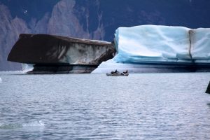
So when my blood starts pumping each year in anticipation of the coming flood, naturally I turn to the Owyhee. Last spring I was lucky enough to witness Owyhee Falls on April 18, the day the river flows peaked in that part of the desert during a trip which began near the East Fork headwaters in Duck Valley, and ended just above the reservoir 190 river miles downstream. We floated two 14’ rafts on a 17-day trip through Idaho’s own Grand Canyon of the Owyhee. For one day the Rome gage was roughly 20,000cfs and the hydraulic dynamics from the raging surge above created waves in the bottom of the massive Owyhee Falls which stacked upon themselves in such a manner as to stir memories of Hermit rapid on the Grand Canyon of Colorado. Rain showers set off innumerable waterfalls through the canyon. The experience felt nothing short of religious.
The Owyhee is an escape from typical river running. Not only is it an escape from the modern world, but it is also an escape from the escape. Even if you only experience it once in a lifetime, the sheer wildness of the Owyhee Canyonlands is something any wilderness enthusiast would cherish. A rafting trip in the upper stretches will be relentlessly trying – it is extremely rare to float the East Fork with only one portage, as it is much more likely to battle low water than big water. On our trip, we faced rain, snow, bitter wind, portages, and lining. We were rewarded with Mountain Sheep viewing in the sunshine at a place aptly named on a BLM map “Heaven’s Window.”
Jon Green Floating Through Lambert Gorge photo: Shane Moser
Don’t come without an adventurous spirit, but if you want to see ‘The West’ in its rawest form, please do come to Idaho’s Southwestern high desert. Your best chances for good rafting flows are between mid-April and the beginning of June. And the trip doesn’t have to last 17 days… Wilderness River Outfitters offers guided trips on different segments of the river, breaking the Owyhee into several shorter multi-day trips rather than one long one – all the way to the reservoir if you so choose. WRO also runs the Jarbidge/Bruneau segments, which typically run a week to a month later on in the season than does the Upper Owyhee. If you can be flexible with timing when booking such a trip, we can wait for the water and run custom trips when best timing presents itself.
On an important side note, the watersheds of the Owyhee and Jarbidge/Bruneau historically held runs of native spawning Salmon and Steelhead. Dams have long since caused the extinction of those native runs of Idaho’s lifeblood, threatening the entire infrastructure of every ecosystem that used to hold spawning waters for the anadromous fish. If you understand anything about the natural cycle of Salmon and Steelhead, or the hydrologic cycle in the desert – or both – you will find it remarkable that there were actually strains of Pacific Salmon and Steelhead that made their way up the Columbia and Snake Rivers to spawn in the muddy, sandy tributaries of Idaho’s desert rivers. Even if you don’t understand much about the natural cycle, you may be interested in helping bring our wild runs back. Please check out “Running the Gauntlet,” a PBS documentary put together by an Idaho river guide.