East Fork Owyhee Trip Report
March 18, 2016
The snow has started to melt, the birds are arriving, and the grass is starting to show around the office. You know when this starts to happen that it’s time to keep an eye on the Owyhee River gauges. Recent warm weather in Southern Idaho has started melting the valley floor snow and low elevation snow. The Owyhee gauges were starting to show the run off and it seemed like a good opportunity to try and catch the runoff in the East Fork Owyhee, so I packed up the dry bags for the first time this year and headed for the desert.

Overlooking Battle Creek confluence and Owyhee River Photo: Seth Tonsmeire
We arrived at Garat Crossing on the East Fork (Upper Owyhee) to see good flows, which is always a relief. With the upper sections of the Owyhee there is always some mystery as to whether or not you find water at a desired put in. There are so many tributaries between gauges you never really know where the water is coming from without going to the river and getting a first hand look. With the good flow, we rigged a few rafts and headed down stream. We spent the first day meandering through the East Fork in the sun shine down to Battle Creek where we made camp the first night.
[youtube]pvoR9UHFR8w[/youtube]
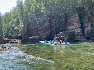
We laid over at Battle Creek our second day and took an awesome hike across the rim and down to the ephemeral springs pool of Yatahoney Creek. The views on the Owyhee looking up at the canyon walls are impressive, but climbing to the rim for the overview look of the canyons are my favorite views. You can probably tell that from my photos! Battle Creek more than doubled the flow of the East Fork, so when we left camp the third day if felt like we were on a real river as we rushed through the willows of the Owyhee. We camped at Deep Creek our third night and even though the river was now on the way down, Deep was still adding good flow. We laid over at Deep and took another nice hike to get the view overlooking the confluence. This is a classic view of the Owyhee Canyon, and the view chosen by the BLM for the cover shot of their latest guide book. The view was chosen for good reason!

Confluence of Deep Creek and East Fork Owyhee Photo: Seth Tonsmeire
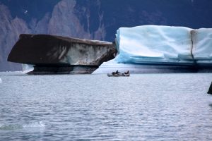
After we packed up from Deep Creek and headed down into Lambert Gorge, my personal favorite section of the whole Owyhee River system. The steep and often vertical rock walls of the gorge come right to waters edge. We took a nice hike mid day to get an overlook and impressive view of Owyhee Falls deep in the canyon below. Besides the hard to predict flows, Owyhee Falls is another reason this section sees so few visitors. This boulder choke rapid in a tight gorge makes for a long and arduous portage high above the river on the grassy slope. After portaging one raft we decided to line the second boat through the rapid opposed to carrying it around. With the descent flows, the falls looks like a pretty ideal flow if you were going to fire up running the rapid. The BLM notes Owyhee Falls as a class VI rapid, although it does get run on occasion, which technically makes it class V. It’s a solid class V with a must make entry move that will make you sick to your stomach thinking what would happen if you messed up the entry. In all the years my dad ran the East Fork canyon, he ran Owyhee Falls nine times, the last time turning over putting his success rate just under 50 percent. For the best boatman I have ever known to make it through right side up only 50 percent of the the time says something about the rapid. I have not run Owyhee Falls yet, but with flows like we had and a bigger crew for safety, it would be a hell of ride!

Lambert Gorge Owyhee River Photo: Seth Tonsmeire
After finishing the Owyhee Falls portage we floated out of Lambert Gorge to Crutchers Crossing, one of the cherry stem road access points into the East Fork. This was our take out point for this trip. We camped at Crutchers that last night. We woke up to rain for three or four hours. For anyone that has visited the Owyhee Canyonlands after a rain storm, you know rain and dirt road travel is not a good combination in this area. The dirt of the Owyhee has clay in it and it turns to slick and often impassable conditions very quickly. After waiting through the morning for the shuttle vehicles to arrive we were starting to think they were not going to make it in. Mid afternoon they showed up covered in mud and stories of struggles. Standard Owyhee adventure, to go rafting it almost always requires some 4X4ing in the desert! After several hours of UTV mudding, we made it back to the trucks about dark.

Owyhee Access Vehicle
It was good to get back on the river for the first time of the season. Turning off the cell phone and taking a break from email and the technology that surrounds us in the world for a week is refreshing for the soul. It’s was so good spending time hiking and floating in one of the most beautiful river canyons of the world! It makes you wish the Owyhee Canyonlands rivers had a more predictable spring runoff that would allow more people the opportunity to explore this amazing wilderness.

Looking out from Crutchers Crossing toward confluence of South Fork and East Fork Photo: Seth Tonsmeire
This warm weather and March snow melt event took the Owyhee basin from the highest snowpack in the state to one of the lowest. It is still holding about 87% of normal, but it does make me a little nervous about the upper trip we have planned for late April. We are still planning to run trips on the Owyhee in 2016, but it might be a better bet for running something lower in the watershed like the Middle Owyhee from Three Forks to Rome on April 28th – May 1st or the Lower Owyhee May 2nd – 6th.
The Jarbidge Bruneau is the next drainage over and the snowpack for that river is higher elevation. That combined with no irrigation demands on the watershed, make it much more predictable. With the snowpack at 118% of normal in the Bruneau basin, we are looking good for trips in May. Our first Jarbidge Bruneau on May 14th is full, but we still have space available on May 22nd – 27th. If you have been thinking about a trip on the Bruneau, this could be the year. Personally I can’t wait to get back down to the Owyhee Canyonlands Wilderness for more spring whitewater boating!
Cheers,
Seth Tonsmeire